For players navigating the raw survival environment of The Isle: Evrima, the map is not just scenery—it’s strategy. Understanding the Evrima map in its full complexity is critical to thriving as a dinosaur in this evolving, immersive simulation. If you’re here searching for what the Evrima map includes, how to use it to your advantage, where spawn zones are located, or how terrain shapes gameplay, this article provides a thorough, current overview based on the in-game experience—not scraped from third-party sites, but broken down for players who want clarity, depth, and real advantage.
What Is “The Isle: Evrima”?
Before diving into the map itself, a quick refresher: The Isle is an open-world dinosaur survival game developed by Afterthought LLC. “Evrima” is the name of the game’s reworked and current development branch, meaning “discovery” in Greek. It’s a complete overhaul from the original Legacy branch, introducing revamped systems, new graphics, better AI, and an entirely reimagined map that’s more realistic and immersive.
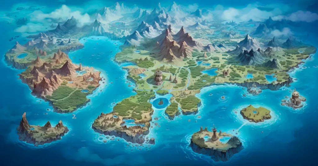
The Evrima map is the only playable map in the new version of the game and differs dramatically from the previous Legacy maps in both layout and function. It supports realism-focused gameplay where topography, water sources, and environmental storytelling directly influence survival.
Key Features of the Evrima Map
| Feature | Description |
|---|---|
| Map Size | ~15 km x 15 km (estimated), dense with environmental variety |
| Biomes | Forests, wetlands, coastal cliffs, rivers, plains |
| Water Sources | Rivers, lakes, and hidden springs essential for survival |
| Spawn Points | Spread across multiple zones to prevent player clustering |
| Landmarks | Include the Dam, River Delta, Swamp, and Logging Camp |
| Navigation Tools | No HUD or minimap; players use landmarks and memory |
The Role of the Map in Gameplay
The Evrima map is more than a backdrop—it is integral to how you survive. From the moment you spawn, you must consider:
- Where are nearby water sources?
- What kind of cover or foliage is available?
- Is this a predator-heavy or herbivore-heavy area?
- Are there known nesting grounds or traffic hotspots?
Unlike typical games with compass-driven navigation, The Isle: Evrima strips away tools like GPS, forcing players to read terrain, memorize features, and track behavior patterns.
Biome Types and Their Functions
Evrima’s map is composed of interlocking biomes, each with unique benefits and hazards. Understanding each can determine the life expectancy of your dinosaur.
| Biome | Description | Survival Impact |
|---|---|---|
| Forest | Dense trees, limited sightlines, strong for ambushes | Excellent for hiding and nesting |
| Plains | Open fields with tall grass, great for herbivores | Exposed to predators, but good for grazing |
| River Zones | Flowing water with accessible banks | Critical for hydration, often contested |
| Swamps | Waterlogged zones with low visibility | Ideal for stealth; dangerous if ambushed |
| Cliffs and Mountains | Elevated terrain with limited access | Great for spotting threats; hard to reach water |
| Coastline | Edges with ocean views and rocky outcrops | Rarely used but scenic and navigable |
Players often rotate through these biomes as they grow, choosing safety or food availability depending on their species and lifecycle stage.
Spawn Points and Traffic Zones
Player spawn locations vary depending on the dinosaur selected and game mode. While exact spawn points shift with updates, several key zones have become known hotspots for spawning, interaction, and conflict.
| Area | Likelihood of Spawn | Description |
|---|---|---|
| Swamp North | Medium | Thick vegetation, good for stealth species |
| Delta Zone | High | Common spawn area, but dangerous due to heavy traffic |
| Logging Camp Area | Low | Central, industrial ruins, useful for landmarking |
| Northwest Cliff | Low | Hard to reach but visually distinct |
| Eastern River Fork | High | Frequent drinking spot, popular for ambushes |
| Southern Flatlands | Medium | Open grazing area, often used by herbivores |
Knowing these can help new players avoid instant death or predator traps, while experienced players can use them for strategic ambush or group formation.
Notable Landmarks and Their Gameplay Uses
Some locations are more than pretty scenery—they’re strategic hubs or points of reference.
| Landmark | Strategic Use |
|---|---|
| The Dam | Central hub, used for navigation; water source nearby |
| River Delta | High interaction zone; drinking and combat are frequent |
| Logging Camp | Human-made structures provide hiding and landmarking points |
| Swamp Cavern | Dense and dark, perfect for nesting or ambushing |
| Mountain Peaks | Clear visibility, but risky due to lack of cover or water |
| Ravine | Often used as a choke point; dangerous but rewarding |
These landmarks help players orient themselves in a world with no map interface and no directional cues other than natural features.
Navigational Strategy: Surviving Without a Map
The Isle: Evrima offers no minimap, compass, or HUD navigation. Players must use:
- Sun position: Morning sun rises in the east, sets in the west
- River flow: Following or crossing rivers helps find water and landmarks
- Sound cues: Audio travels based on terrain; open areas carry sound further
- Landmark chaining: Linking known spots to build a mental map
- Animal behavior: Movement of AI creatures or tracks can point to water or danger
These mechanics make navigation itself a survival skill, separating experienced players from newcomers.
Growth and the Role of Territory
As players progress, territory becomes increasingly important. Larger, older dinosaurs need:
- Secure water sources
- Low-traffic areas for rest
- Access to nesting sites
- Proximity to herds or packmates
For apex predators like Tyrannosaurus Rex, controlling river crossings can dominate gameplay. For small species like Compsognathus, knowing back routes through dense brush is life-saving.
PvP and Hotspots
The Evrima map naturally shapes player-vs-player (PvP) interaction. Certain zones are notorious for high confrontation:
| PvP Hotspot | Description |
|---|---|
| Eastern River Fork | Predators stalk herbivores at popular watering hole |
| Central Swamp | Dense ambushes, especially from smaller carnivores |
| Delta Valley | Mixed-species territory wars are common here |
| Dam Ridge | High ground makes for strategic advantage in fights |
For players seeking to avoid conflict, sticking to coastal or highland zones can provide a quieter experience.
Nesting and Group Play Zones
Nesting plays a growing role in Evrima. Certain terrain types are better suited for:
- Concealment from aerial view
- Protection from pathfinding predators
- Access to food/water within range of hatchling radius
Popular nesting zones include:
- Western Pines: Isolated, shady, and quiet
- Ravine Entry Slopes: Steep approaches deter attackers
- Southern Lakebanks: Easy access to food and water
Groups often claim territory, and communicating safe zones becomes critical for survival in community servers.
Resource Distribution
The map’s food and water are not evenly distributed. Knowing where to find these resources can mean the difference between growing or starving.
| Resource | Location Pattern |
|---|---|
| Water | Rivers, springs, and hidden swamp pools |
| Plant Food | Grasslands and riverbanks; density varies |
| Carrion/Meat | Spawns near high-traffic or carcass zones |
| AI Creatures | Appear most in forests or low-visibility areas |
Hunger mechanics drive movement and conflict, creating dynamic migration routes across the map.
Future Expansions: What’s Coming to Evrima Map?
Developers have hinted at upcoming expansions to the map, including:
- Volcanic regions
- More human ruins or lore sites
- Interactive weather systems that affect navigation
- Seasonal biome changes
These will likely affect spawning, visibility, and survival mechanics, further deepening the map’s complexity.
Community Tools and Unofficial Maps
While the game offers no in-game map, the community has built:
- Fan-drawn maps based on coordinates and exploration
- Third-party overlays that annotate known landmarks
- Server-based GPS mods for private servers
However, hardcore players often choose to play blind, embracing the immersive challenge of mapless survival.
Comparison: Evrima Map vs Legacy Map
| Feature | Evrima Map | Legacy Map |
|---|---|---|
| Terrain Detail | High realism | Simplified terrain |
| Size | Larger | Smaller |
| Navigation Tools | None | Mini-map available |
| Biomes | More varied | Mostly forest/plains |
| Player Distribution | More dynamic | More clustered |
Evrima map introduces a new standard of organic, player-shaped geography—less about waypoints and more about awareness.
Final Thoughts
The Evrima map in The Isle is not just terrain—it’s a living, breathing environment that shapes every decision you make. From its uneven resource distribution to its reliance on natural navigation, the map transforms a survival game into an experience of raw immersion. Knowing the land is not optional—it’s vital. Whether you’re a lone carnivore stalking prey or a herd animal seeking safety in numbers, mastery of the map is the single greatest tool in your survival kit.
Understanding Evrima is not just about where you are—it’s about what that place means, how others interact with it, and how it fits into a constantly evolving ecosystem. For players who want not just to play but to thrive, this knowledge turns terrain into strategy and survival into art – The Isle Evrima Map.
FAQs
1. Does The Isle: Evrima have an in-game map or compass?
No. The Isle: Evrima intentionally omits any in-game map, compass, or directional HUD to promote immersion. Players must navigate using natural landmarks, the sun’s position, river flow, and memory.
2. Where are the safest places to spawn or survive as a new player?
Relatively safer areas include the western pines, coastal cliffs, and southern flatlands—zones with lower traffic and more foliage for hiding. However, safety can vary depending on the time of day and server population.
3. What are the major landmarks on the Evrima map?
Key landmarks include The Dam, River Delta, Logging Camp, Swamp Cavern, and Eastern River Fork. These areas help players orient themselves and are often hotspots for resources or conflict.
4. How do I find water or food without a map?
Follow rivers and observe AI animal behavior—they often lead to water. Herbivores can find food in open plains and near riverbanks. Carnivores must rely on hunting, carcasses, or ambient AI spawns.
5. Will the Evrima map be expanded in future updates?
Yes. Developers have confirmed ongoing expansion plans, including new biomes, human structures, dynamic weather systems, and terrain enhancements that will further evolve survival strategies.